GENERAL INFORMATION
Frecuency: 285.0 kHz
Location: LG Lugo, Spain
Coordinates: 431453n 72853w
Power: 1000w
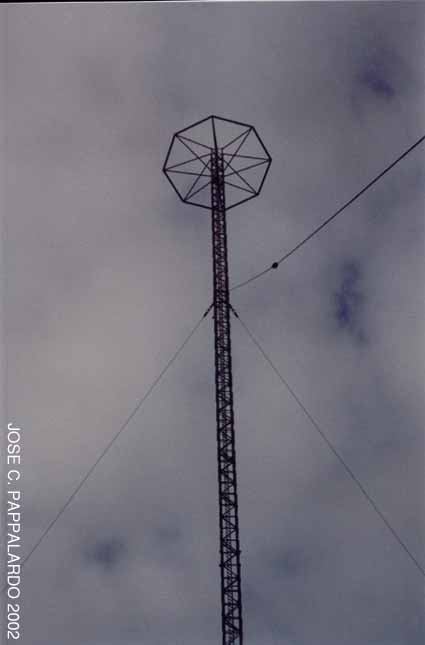
Height: 112 ms
DATOS GENERALES
Frecuencia: 285,0 kHz
Ubicacion: LG Lugo,
España
Coordenadas: 431453N 72853W
Potencia: 1000W
Altura: 112 m
HISTORICAL INFO
Installed
by the Germans before the beginning of World War II; its original name
is SONNE (SUN in english or SOL in Spanish). The central mast
broadcasted the main signal, the lateral masts were used to broadcast
the same signal moved of phase to simulate a wave of slow rotation.
That rotation was synchronous with a Morse code giving a direct
indication of the location, the only necessary equipment was a
chronometer clock and a BEACON band frequency receiver. That simple
equipment gave a rank of up to 1000 miles with a precision of average
to high depending on the hour of the day and the distance. It was
installed by the Germans to give cover to waters of the Atlantic. The
system was perfectly known by the allies that also used it, that was
the reason wy the sites were never bombed. During World War II there
were three stations working in Germany, one in Brest (France) and this
of Lugo, Spain. Name CONSOL was given by the allies like a joke meaning
" With Sun ". In France one stayed in operation until the decade of the
60. In Spain it was military property used by the Civil Aviation. I
don't know the date of closing of the station. Recently I have found
out that these stations were known technically like ELECTRO-SONNE, and
that Professor RV JONES was the one who issued the order of Not bombing
them during the war.
DATOS HISTORICOS
Instalado
por los alemanes justo antes de inicio de la II Guerra Mundial; su
nombre original es SONNE (SUN en Ingles o SOL en Castellano). El mastil
central radiaba la onda principal, los mastiles laterales eran
utilizados para radiar la misma onda desplazada de fase para simular
una onda de rotacion lenta. Esa rotacion era sincronizada con un codigo
Morse dando una indicacion directa de la ubicacion, el unico
equipamiento necesario era un reloj cronometro y un receptor de
frecuencia de banda BEACON. Ese simple equipamiento daba un rango de
hasta 1000 millas con una precision de media a alta dependiendo de la
hora del dia y la distancia. Fue instalado por los alemanes para dar
cobertura a las aguas del Atlantico. El sistema era perfectamente
conocido por los aliados quienes tambien lo utilizaron, esa era la
razon por la cual nunca se bombardeo. Durante la II Guerra Mundial
habia tres estaciones funcionando en Alemania, uno en Brest (Francia) y
esta de Lugo, España. El nombre CONSOl fue dado por los aliados como un
chiste significando "Con Sol". En Francia se mantuvo en funcionamiento
hasta la decada de los 60. En España paso de ser propiedad militar a
ser de uso de la Aviacion Civil. Desconozco la fecha de cierre de la
estacion.
Recientemente
he averiguado que estas estaciones eran conocidas tecnicamente como
ELECTRO-SONNE, y que el Profesor RV JONES fue quien dio la orden de no
Bombardearlos durante la II Guerra Mundial.
NEW INFO 28-09-2001
The station was military property until year 1962, date in which it was passed over to the Civil Aviation
Authority in whose hands it stayed until 1971, date of closing and abandonment.
During
World War II, there was a failure in the antennas. The real problem
arose when the Germans were not able to make arrive the spare pieces to
Lugo (I don't know the reason) and that the British finally provided
the pieces. A clear example that proves that these antennas were used
by both sides.
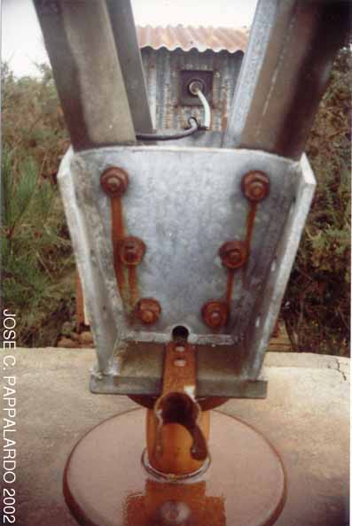
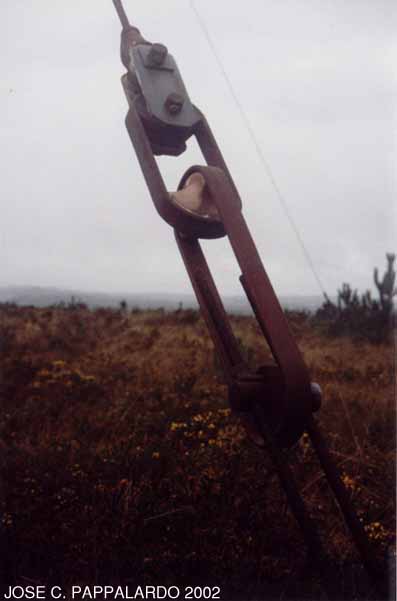
There is an exact distance of 2823,104 meters between each antenna.
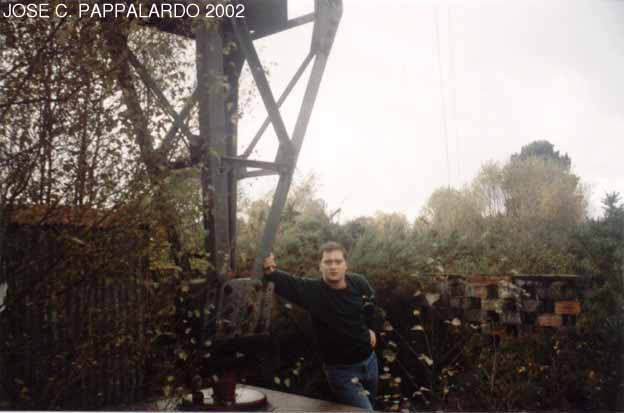
Next
to the central antenna there were two constructions. A transmission
platform (?) and another formed by a dormitory, a kitchen, a living
room and a garage.
This historical relic is known in the area as: THE TOWERS OF ARNEIRO
ULTIMOS DATOS 28-09-2001
-La
estacion fue propiedad militar hasta el año 1962, fecha en la que paso
a ser de la Autoridad de Aviacion Civil en cuyas manos se mantuvo hasta
1971, fecha de cierre y abandono.
-Durante la II Guerra Mundial, hubo
algun tipo de averia en las antenas. El autentico problema surgio
cuando los alemanes no fueron capaces de hacer llegar las piezas de
repuesto a Lugo (desconozco el motivo) y que fueron los britanicos los
que suministraron las piezas. Claro ejemplo de que estas antenas eran
empleadas por ambos bandos.
-Hay un distancia
exacta de 2823.104 metros entre cada antena.
-Junto a la antena central hubo dos edificaciones. Una plataforma de transmision
(??) y otro formado por un dormitorio, cocina, sala de estar y garaje.
-Esta reliquia historica se conoce en la zona como:
LAS TORRES DE ARNEIRO
STATE OF CONSERVATION
The north antenna is in a state of conservation of 8 points (0-10) next to an inhabited house.
The central one is a little damaged since it is isolated in the middle of a marshy land next to the cemetery (5 points).
The
south one is a bit like the north one: next to a house with guard dogs,
so if you decide to visit this one, please request permission to chap
in the house before you get bitten. The hut of this antenna is the best
conserved (9 points).
ESTADO DE CONSERVACION
La
primera antena se encuentra en un estado de conservacion de 8 puntos
(0-10) junto a una casa habitada. La segunda es la mas dañada ya que
se encuentra aislada en medio de un terreno pantanoso junto al
cementerio (5 puntos). La tercera se encuentra en una situacion similar
a la primera: junto a un chalet vigilado por perros, asi pues, pedir
permiso a los de la casa antes de acceder a la antena para evitar
alguna mordedura. La caseta metalica de esta antena es la mejor
conservada (9 puntos).
Winter 2003 / Invierno 2003
I
have recently revisited the site discovering several changes in the
area. There is now a wide road crossing the area which complicates the
approach by car to aerials Nº1 & Nº2.
The good news is that I
have located at last the buildings that belonged to the complex:
A water tower, a garage
and several small structures with destroyed technical equipment. All coming soon!
Recientemente
he revisitado el lugar descubriendo varios cambios en la zona.
Actualmente hay una gran carretera que cruza la zona, lo cual complica
el acceso mediante coche a las antenas Nº1 y Nº2.
Lo bueno es que he localizado los edificios que pertenecían al complejo:
Una torre de agua, un garaje y varias pequeñas estructuras conteniendo equipación
técnica totalmente destruido. Todo ello muy pronto aquí!

|